Storm brings potential for damaging gusts this weekend
Date published: 04 December 2015

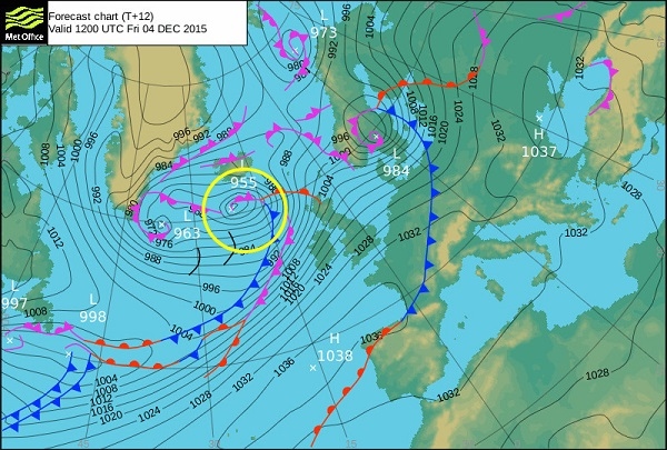
Forecast position of Storm Desmond at midday Friday 4 December
The current unsettled spell of weather continues with Storm Desmond, the fourth named storm of the season, bringing the potential for damaging gusts across northern Britain at times.
The storm itself is a low pressure system passing well to the northwest of the UK, close to Iceland but will bring a windy weekend to the whole of the UK.
Two periods of severe gales with the potential for damaging gusts to northern areas are expected - the first spell across Scotland and northern England on Friday afternoon and into the night, followed by another on Saturday afternoon and evening, especially across south-east Scotland and north-east England.
The frontal systems associated with Storm Desmond will also bring persistent rain to some parts of northern Britain - the heaviest rain is expected on west facing hills and mountains from north Wales northwards.
Frank Saunders, Chief Operational Meteorologist, said: "Although Storm Desmond itself is a long way from the UK, it will bring us all a windy weekend.
"The gales will be strong enough across many northern areas, to bring down some trees, and perhaps cause damage to buildings. Anyone travelling should be aware that there could be some travel disruption on roads and ferry routes. We have issued National Severe Weather Warnings for the potential impacts of all this weekend's weather and everyone should keep up to date with these and plan accordingly."
Phil Stockford, Emergency Planning Manager at Highways England, said: "We're advising drivers to plan their journeys before they set out, checking the forecast and road conditions, as well as to leave extra time for their journeys and to delay their journey if the weather becomes severe.
"There's a particular risk to lorries and other vulnerable vehicles, such as caravans and motorbikes, so we're asking drivers to slow down and to avoid using exposed sections of motorways and other routes if possible."
Jonathan Day, Environment Agency Flood Risk Manager, said: "River levels across northern England are already high and are expected to rise with this further heavy rainfall, bringing with them a significant risk of flooding that could cause major disruption to roads and travel. We are working closely with the emergency services and partners to prepare ahead of the weekend. Our teams are already in action clearing watercourses, maintaining existing defences and deploying temporary defences where these can be effective.
"We urge people not drive through flood water: just 30cm of flowing water is enough to move your car. People should check their flood risk and keep up to date with the latest situation at https://www.gov.uk/check-if-youre-at-risk-of-flooding or follow @EnvAgency and #floodaware on Twitter for the latest flood updates."
Do you have a story for us?
Let us know by emailing news@rochdaleonline.co.uk
All contact will be treated in confidence.
Most Viewed News Stories
- 1'Eyesore’ land in the town centre will become home to new apartment block
- 2Contractor appointed for regeneration scheme in Rochdale town centre
- 3Rochdale Exchange Market to reopen after a decade
- 4Castleton station ‘to become epicentre of huge change and growth’
- 5Decision delayed on 445-home estate in Castleton
To contact the Rochdale Online news desk, email news@rochdaleonline.co.uk or visit our news submission page.
To get the latest news on your desktop or mobile, follow Rochdale Online on Twitter and Facebook.

