Guide to the nine new green belt sites included in revised masterplan
Date published: 17 January 2019

Land at Firgrove
When Greater Manchester Mayor Andy Burnham demanded a ‘radical rewrite’ of the region’s development masterplan, local leaders were sent back to the drawing board with his ambition for ‘no net loss of green belt’ ringing in their ears.
At an unveiling of the new draft last week it was clear this target had not been achieved, due - Mr Burnham claims - to the government not allowing councils to plan using more recent population projections.
However, the total amount of green belt space under threat has roughly halved under the new plan, with a further 65 patches of land earmarked for green belt status.
And under the new blueprint, no Greater Manchester borough is set to be greener than Rochdale - thanks in part to nine new parcels of land being designated as green belt for the first time.
Under the previous plan, which emerged in 2015, Rochdale was set to lose 4.6% of its green belt.
But due to officials focusing more on ‘urban area’ sites, dropping the Lane End proposal and reducing ‘green belt take’ at the Northern Gateway, Stakehill and Kingsway South sites there will be a loss of only 2.9% - meaning 59.9% of the borough will remain as green belt - the highest in the region.
Some current areas of green belt would be lost under the new plan - including at new sites at Crimble Mill, Castleton Sidings and Newhey Quarry.
However, while some 645 hectares of land are earmarked for development this will be offset by 175 hectares which are to be protected for the first time.
This land is split across nine different sites across the borough.
Land at Firgrove Playing Fields
These playing fields, off Belfield Lane, are sandwiched between Rochdale Canal in the west and the River Beal to the east.
The recreational facilities play host to a range of sporting activities, including football and rugby, and there is also a play area.
Firgrove is immediately to the south of the playing fields, while the area of Belfield is to the west and Milnrow is to the south.
The 16-hectare area is protected by independent charity Fields in Trust ‘into perpetuity’.
Although this is not equivalent to green belt designation it has led to accusations from some quarters that the amount of ‘new green belt’ in Rochdale has been exaggerated.
Liberal Democrat leader Andy Kelly has branded it a ‘smoke and mirrors’ on behalf of the council.
However, local authority bosses will point to the fact this was not designated as green belt land in the earlier draft and would enjoy an enhanced level of protection should the new plan be adopted.
Heywood
- Land at Queens Park
- Land at Summit
An award winning, 16-acre Victorian park, this much-loved area is adjacent to the proposed Crimble Mill and Mutual Mills development site.
Featuring tranquil gardens and a picturesque lake, it has recognised with Green Flag status – the national benchmark for excellence in the management of parks and green spaces.
It offers a range of recreation and leisure facilities for visitors, while original buildings and structures include the Lodge House and Victoria Fountain.
However, as with Firgrove Playing Fields, the designation of this as ‘new’ green belt has been criticised.
Conservative councillor, Pat Sullivan has claimed it is ‘ridiculous’ to include park land in the figure.
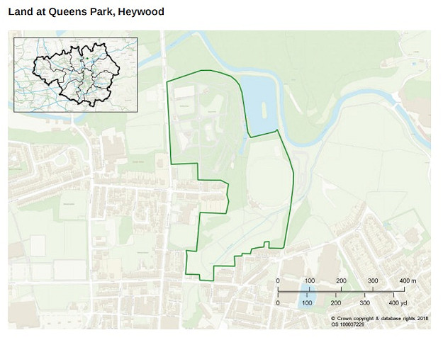
The spatial framework draft stresses that any proposal for the Crimble Mill site ‘should demonstrate how high quality physical and visual links to the park could be created’
It is just under three miles as-the-crow-flies from Junction 19 of the M62, where a new link road is to be built to the huge new Northern Gateway development around Heywood Distribution Park.
Also nearby are Heywood Sports Village and Marland Golf Club.
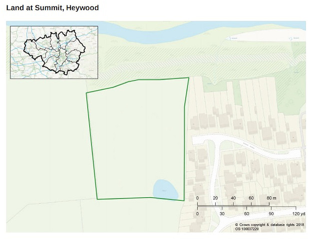
And, about a mile-and-a-half from Queen’s Park – just south of the River Roch – is a small 1.4-hectare green belt site at Summit.
Its eastern flank border would flank homes in Welland Avene, Summit Street and Severn Road flank its eastern border. Bury New Road lies to the south.
Littleborough
- Land between railway line and Rochdale Canal
- Land at Town House Brook
- Land north of St Andrew’s Church, Dearnley
- Land north of Shore
The town of Littleborough, in the north of the borough is earmarked for 300 new homes at Smithy Bridge and a further 210 within the Roch Valley.
But it also has the greatest concentration of proposed new green belt sites in Rochdale – part of a strategy to offset the impact of new developments while taking advantage of the leisure and recreational opportunities the area offers.
The largest of these is a 9.4-hectare area between Rochdale Canal and the railway line.

Halifax Road runs to the east of the site, while immediately to the west lie the industrial units of CRP Ltd, PDS and Ken Mills Engineering.
To the west of this site, just on the other side of Todmorden Road, is Townhouse Brook, where another 4.8-hectares of land is proposed to become green belt for the first time.

Homes in Redland Close, Dearden Street and Ferrand Street lie immediately to the south, while the site is also next to Littleborough Cricket Club and Harehill Park.
The second biggest area of new Rochdale green belt in the plan is land to north of St Andrew’s Church, in Dearnley.
The 8.8-hectare site, off Arm Road, sits just to the north of New Road.
Also in close proximity are St Andrew’s CE Primary School, Dearnley Post Office, Kingdom Hall and the Green Door Restaurant.
Nearby residential streets to the south are School Street and Crowther Street, while those to the west include Oakley Way, Wayfarers Way and Joseph Lister Drive.

The final allocation in Littleborough is a 2.7-hectare area to the north of Shore.
This is close to the residential area off Shore Road, including Abberley Fold, Melrose Avenue and Tintern Avenue.
Heights Farm lies to the west.

Land to the west of Stakehill Industrial Estate, Middleton
At 47-hectares, this one is the biggest single contribution to Rochdale’s 175-hectares of new green belt.
Whit Brook runs through the site, and its eastern border stretches along the perimeter of the industrial estate to Slattocks Roundabout.
It extends out westwards towards Cardinal Langley RC High School and Stannycliffe, with Rochdale Road acting as a border.
Boarshaw Lane acts as the southern perimeter of the side.

The extension of Stakehill Industrial Estate – also referred to as Northern Gateway 2 – has been scaled down significantly since the last spatial framework draft, allowing for this parcel of land to be added to the green belt.
Being just a mile from Mills Hill train station, the site is easy to get to and is likely to feature in council plans to open up the green belt for recreational and leisure.
Land within Roch Valley, Smallbridge
At 69-hectares, this is the biggest of all the green belt sites – but not the main contributor of ‘new’ protected land, as only nine of its hectares were not included last time round.
The site contains Clegg Hall Trout Fisheries and is easily accessible from Smithy Bridge Railway, which is close to its eastern border.
Just to the east is the suburb of Smithy Bridge and Hollingworth Lake, one of the borough’s key tourism destinations.

As with land to the west of Stakehill Industrial Estate, the area has a rail line close by and has the potential provide the recreation and leisure opportunities for visitors and future residents – some of whom may live in the 210 new homes earmarked for the Roch Valley.
This site is essentially bounded by the River Roch to the north and the rail line to the south, while Albert Royds Street and the River Beal lie to the west.
Residential streets on the western fringe of the site include Cloverhall Crescent, Bellshill Crescent and Blackstone Avenue.
Hursthead and Smallbridge lie to the north, while to the south are Firgrove and Belfield.
Nick Statham, Local Democracy Reporter
Do you have a story for us?
Let us know by emailing news@rochdaleonline.co.uk
All contact will be treated in confidence.
Most Viewed News Stories
To contact the Rochdale Online news desk, email news@rochdaleonline.co.uk or visit our news submission page.
To get the latest news on your desktop or mobile, follow Rochdale Online on Twitter and Facebook.
